In questi giorni il team di bioingegneri composto da Arti Ahluwalia, Carmelo De Maria e Chiara Belmonte si trova a Nairobi per tenere un corso intensivo nell'ambito del progetto Afra Moya, di cui il...
Leggi tutto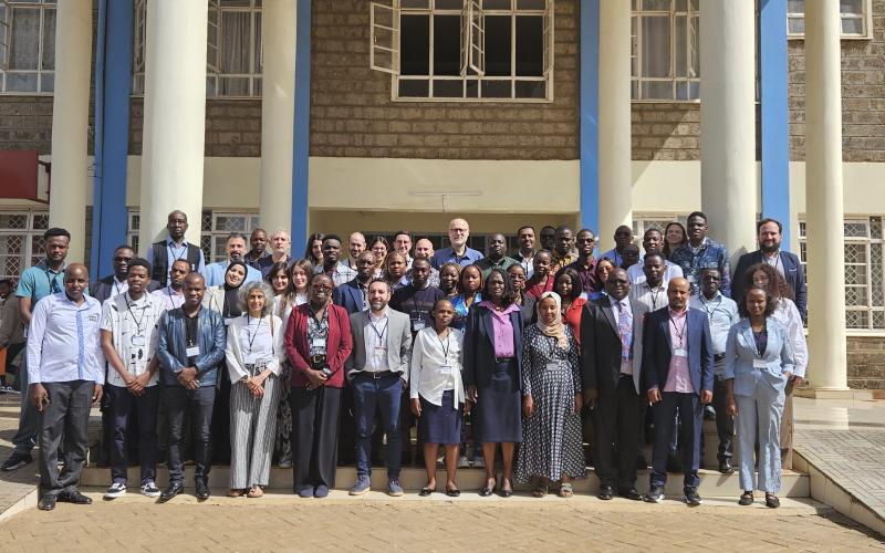

per info fabrizio.lombardini@unipi.it
Abstract
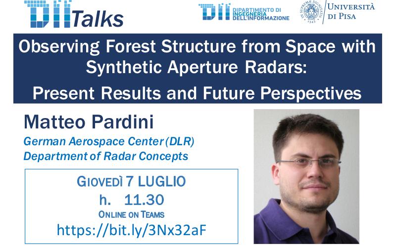
Observing Forest Structure from Space with Synthetic Aperture Radars: Present Results and Future Perspectives Monitoring the impact of ecosystem changes on forest volumes that occur in variable spatial and temporal scales and affect their 3D structure requires a continuous and systematic observation approach. Across the different space borne remote sensing techniques, satellite Synthetic Aperture Radar (SAR) systems play an essential role, as they can realize imaging with wide field of view widths (on the order of 100 km), enabling continuous global scale coverage with high spatial (on the order of 10 m) and temporal (on the order of weekly) resolutions. With increasing wavelength, SAR pulses penetrate more and more into and through the forest canopy, and interact with forest elements located at different heights within the forest volume, as well as with the underlying terrain. However, a single SAR image does not allow a reconstruction of the 3D distribution of radio scatterers within the illuminated volume. For this, a set of SAR images acquired under different look angles is required, in the context of interferometric and/or tomographic SAR measurements.
This seminar reviews and discusses the basics and the potential of interferometric and tomographic SAR configurations to map forest structure parameters. Many experimental results will be presented, obtained in the frame of airborne experimental campaigns in temperate and tropical forest conditions. Besides, large scale country-wide mapping results will be presented obtained with the DLR’s TanDEM-X satellite data. Finally, the role of future SAR spaceborne configurations and missions, in the context of global forest structure and structure change mapping, is illustrated.
Bio
Matteo Pardini received the Ms.Eng. degree in telecommunication engineering and the Ph.D. degree in information engineering from the University of Pisa, in 2006 and 2010, respectively. In January 2010, he joined the Information Retrieval group in the Radar Concepts Department, Microwaves and Radar Institute, German Aerospace Center (DLR) in Oberpfaffenhofen, Wessling, Germany, as a Research Scientist, after a Ph.D. student visiting research period from August to December 2009. In 2017, he was a Visiting Scientist with the Department of Geographical Sciences, University of Maryland, College Park, USA.
His research interests include synthetic aperture radar (SAR) tomographic and polarimetric interferometric processing for 3-D bio/geophysical information extraction over natural volumes (forest, agriculture, and ice), SAR mission design, and SAR mission performance analysis. He is member of DLR’s TanDEM-X and Tandem-L satellite science teams. He was awarded with a IEEE GRSS (Geoscience and Remote Sensing Society) Paper Award in 2019, and the DLR Science Award in 2020.
In questi giorni il team di bioingegneri composto da Arti Ahluwalia, Carmelo De Maria e Chiara Belmonte si trova a Nairobi per tenere un corso intensivo nell'ambito del progetto Afra Moya, di cui il...
Leggi tutto![]()
Dipartimento di Ingegneria dell'Informazione
Via G. Caruso 16 - 56122 - Pisa
Tel +39 050 2217511 - info@dii.unipi.it
PEC: ing.informazione@pec.unipi.it
Info Didattica: didattica@dii.unipi.it
P.I. 00286820501 - C.F. 80003670504